
In this post, I cover how to install the Oracle MapViewer 11g (11.1.1.7) Quick Start Kit. I also tell you where to track down a copy of the data for the MapViewer demos (that is not included with this distribution), and I take you step-by-step through the import of that data and the creation of a permanent data source.
Download Oracle MapViewer
Go to the Software Downloads for Oracle Fusion Middleware MapViewer page and accept the Terms and Conditions. Download the MapViewer Quick Start Kit from the Current MapViewer Version section. The Quick start kit is bundled with Glassfish server version 3.1.2. Alternatively, you can download and unzip the EAR file and then deploy the WAR file from the EAR to Tomcat.
Unzip the file and read the README.txt file located in the mapviewer11g_gs directory.
Install and Configure Glassfish and MapViewer
Installation is simply a matter of following the instructions in the README.txt file.
$ ./runMeFirst.sh
Setting 'admin' user's password to: welcome1 ...
Command change-admin-password executed successfully.
Waiting for domain1 to start ......
Successfully started the domain : domain1
domain  Location: /home/smitchell/Applications/mapviewer11g_qs/glassfish3/glassfish/domains/domain1
Log File: /home/smitchell/Applications/mapviewer11g_qs/glassfish3/glassfish/domains/domain1/logs/server.log
Admin Port: 4848
Command start-domain executed successfully.
Deploying Oracle MapViewer ......
Application deployed with name mapviewer.
Command deploy executed successfully.
Deploying MapViewer Samples application ......
Application deployed with name mvdemo.
Command deploy executed successfully.
Enabling remote secure login
You must restart all running servers for the change in secure admin to take effect.
Command enable-secure-admin executed successfully.
Restarting server ...
Successfully restarted the domain
Command restart-domain executed successfully.
MapViewer QuickStart kit is now running!
MapViewer Server URL: http://localhost:8080/mapviewer
MapViewer Samples URL: http://localhost:8080/mvdemo
Glassfish Admin URL:  http://localhost:4848
Next, remove the one-time-use files used by runMeFirst.sh.
$ rm welcome1.txt
$ rm password.txt
MapViewer is now running. To start and stop Glassfish/MapViewer run the startServer and stopServer scripts.
Configure the MapViewer Demo
The MapViewer Quick Start Kit comes bundled with the MVDEMO war. There is some housekeeping necessary to set up the demo. That is all explained on the MVDEMO homepage: http://localhost:8080/mvdemo/.
Confirm the Required Database Views Exist
Numerous views should have been created in MDSYS when you installed Oracle Enterprise Edition. Open SQL Developer and connect to the database. Scroll down to Other Users. Expand Other Users and find the user MDSYS. Expand the Views folder and scroll down until you come to the USER_SDO_… views (not shown). The following views should be there: USER_SDO_CACHED_MAPS, USER_SDO_MAPS, USER_SDO_THEMES, and USER_SDO_STYLES.
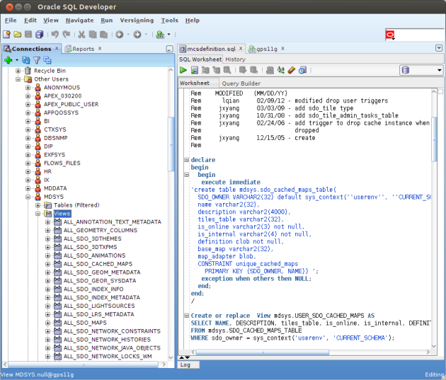
Note that the mcsdefinition.sql file is opened in the right side-panel above. That is a script that creates the necessary views should they be missing.
Import the MapViewer Demo Data
The data for the MapViewer demo is contained in a file named mvdemo.zip. That file is not part of maviewer11g_qs download. I found a copy in mapviewer10133wls.zip. It contains the mvdemo.zip file which, in turn, contains four SQL files, a mvdemo.dmp file, and readme.txt.
Follow the instructions in the file readme.txt included in mvdemo.zip. It walks you through the following steps.
Create new Oracle User
Create a new user, mvdemo. You’ll need that user later to import the demo data, although you may use a different user if you wish.
grant connect, resource, create view to mvdemo identified by mvdemo;
Grant succeeded.
Import the Dump Data
I’m working on two machines, so for this step, I first used secure copy to copy the dump data over to the Oracle database server.
 scp mvdemo.dmp oracle@gps11g:~/
oracle@gps11g's password:
mvdemo.dmp                                      100%  8288KB    8.1MB/s    00:00
From the oracle user account on the database server I ran the import command:
$ imp mvdemo/mvdemo file=mvdemo.dmp full=y ignore=y

Import: Release 11.2.0.1.0 - Production on Sun Jun 9 19:43:47 2013
Copyright (c) 1982, 2009, Oracle and/or its affiliates.  All rights reserved.

Connected to: Oracle Database 11g Enterprise Edition Release 11.2.0.1.0 - 64bit Production
With the Partitioning, OLAP, Data Mining and Real Application Testing options

Export file created by EXPORT:V09.00.01 via conventional path
import done in US7ASCII character set and AL16UTF16 NCHAR character set
import server uses WE8MSWIN1252 character set (possible charset conversion)
export client uses WE8MSWIN1252 character set (possible charset conversion)
. importing MVDEMO's objects into MVDEMO
. importing MVDEMO's objects into MVDEMO
. . importing table                       "CITIES"        195 rows imported
. . importing table                     "COUNTIES"       3230 rows imported
. . importing table                    "EMPLOYEES"         14 rows imported
. . importing table                  "INTERSTATES"        239 rows imported
. . importing table                         "MAPS"          4 rows imported
. . importing table                       "STATES"         56 rows imported
. . importing table                       "STYLES"        285 rows imported
. . importing table                  "TERRITORIES"          9 rows imported
. . importing table                "TERR_COUNTIES"       3230 rows imported
. . importing table                       "THEMES"         10 rows imported
Import terminated successfully without warnings.
Run mvdemo.sql
Readme.txt suggests importing mvdemo.sql from SQL*PLUS; however, I did it from SQL Developer using a new connection authenticated with the new mvdemo user account.
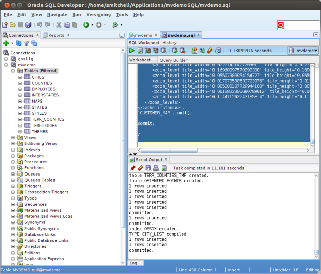
That completes the mvdemo data import.
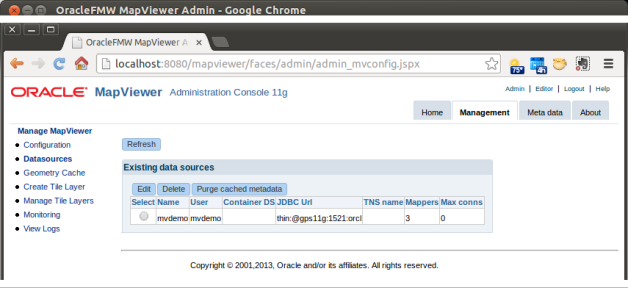
Create the mvdemo Data Source
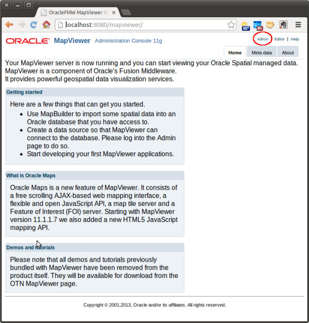
Open the MapViewer Administrative console, http://localhost:8080/mapviewer/, and click the Admin link that I circled in red below.
Follow these steps:
- Sign in with the Glassfish Id and password, admin/welcome1. You may change the Glassfish password by running the resetPassword.sh script.
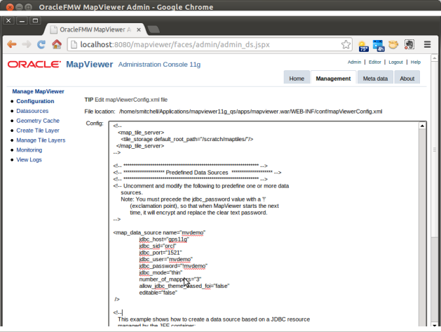
- When the Management page appears click Configuration at the top of the menu on the left side of the page.
- The MapperConfig file will be displayed. Scroll to the bottom of the file to the Predefined Data Sources section.
- Un-comment the mvdemo map_data_source and edit the values to match the database server as shown below. NOTE: the exclamation point in front of the password is not a typo. It must be there.
- Click the Save and Restart button at the bottom of the Configuration page.
Click on the Data sources menu below the Configuration menu after the MapViewer restarts and you’ll see the new data source.
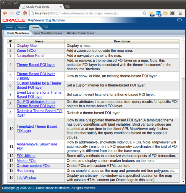
Explore the Demos
You can now start exploring the demos at http://localhost:8080/mvdemo/demo/oracle_maps_demo.jsp.
In my next post I’ll set up the HTML5 demos, that is, once I’ve finished exploring this demo set.
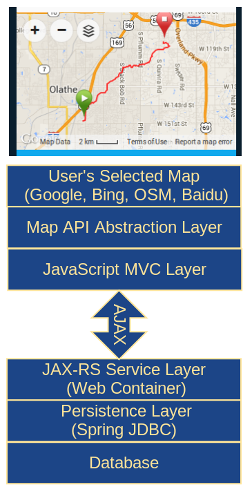 My personal preference is open source and lightweight, as this graphic illustrates, with a client-side JavaScript MVC framework making AJAX calls to JAX-RS web services. The RESTful web services should run in a standard Java web container and not depend on Java EE server containers.